Lack of Navigation skills
Early in 2023 we were invited for a consultation session about safety with the government 專業諮詢會議 - 「我國108年開放山林後,山域活動事故頻繁,相關配套措施是否具足等情」
. There were many points to discuss, and most related to accidents in mountains. One of the discoused problem was related to missing people in the mountains and navigation skills of hikers in Taiwan.
I joined over two dozen searches of missing people in the mountains and many other cases I helped consult or examine. For the purpose of this meeting I made my own "statistics" and made some clear conclusions about reasons for missing persons. In many cases it could be prevented.
Missing is not always lost
It is important to mention that I barely joined rescue cases where the location of the accident is known, for this part official SAR (Search And Rescue - firefighters or volunteers in Taiwan) are well trained and their operation plans are effective. But when a person is missing (location is unknown) is much more difficult to solve and there are various factors why a person is missing and any detail may lead to finding of missing one. Unfortunately there are way too many people still missing and they may not ever be found which is not only sad but very troubling for the deceased.
For simplicity of this article we can focus on cases of missing hikers in mountains, but there were many cases of missing citizens which included elderly or suicides or even car accident in mountains with unknow location. It is extremely important that family members of missing persons provide honestly any detail about missing persons. Searching for a missing hiker or person who had life difficulties (dementia, money, relationships,...) is way different.
But there are various reasons why hikers went missing and it is important for SAR understand missing person navigation skills and set probability towards following scenario:
- Missing because LOST (因為「迷途」而失蹤)
- Missing because ACCIDENT (因為「意外」而失蹤)
- Missing because OTHER (suicide, elderly,..) (其他:自殺、)
It may not be clear at the beginning of the search, but we always ask relatives if a missing person has a habit of using a GPS device for navigation. If a person is skilled with GPS navigation then the probability of getting lost is low, but not zero. On the other hand, if a missing hiker has no skills using GPS navigation then being lost may be the main reason. Together with many other details and tons of work may lead to finding the missing one.
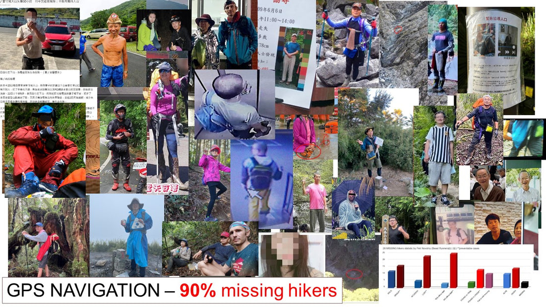
Petr`s statistic of 28 cases of missing persons (till 2022)
Below are main factors when person got missing or how was found, these factors are easily preventable (**可預防的) with basic knowledge of GPS navigation and knowing cannot descent mountains out of trail for every member in mountain group.

Conclusion from Petr`s statistic and what can be prevented:
- It may sound that SOLO hiking is more dangerous but from the above statistic is a surprise that GROUP or team hikes lost their members more often, in most cases missing members had no navigation skills. Hike with known team members and avoid joining self organised groups if you are a beginner.
- LOST - Majority of missing cases which Petr joined were lost because of lack of navigation skills, these all could be prevented if hikers know how to use GPS navigation (offline map) and properly backup GPS devices (have two GPS devices and enough power supply).
- OFFLINE MAP - Majority cases had no idea how to use offline maps or even provide coordinates to emergency hotline (7 missing person actually call about getting lost with smartphone, two of them are still missing. Only one know how to provide coordinates, 4 person got discharged phone or had not signal)
- CREEK - Many lost hikers who got lost decided to descend randomly from mountains which is a huge mistake. Only one person went out from the mountains after two days by himself, rest need to be rescued and often found dead or are still missing.
- TRAIL - Four cases of alive were found on wild trails. It is the highest chance you will be found alive and early if you stay on a trail or some path (in Taiwan often marked by ribbons). But this needs certain patience and focus on how to survive incoming night in mountains, especially temperature comfort. But that is a topic for another article about essential gear.
So from above we can clearly see learning how to use GPS navigation is essential for all hikers in Taiwan or around the world. But even if a person is not an active hiker it is good to have basic navigation tools in their smartphone, simple OFFLINE MAP. Please teach your friends and relatives to have an offline map in their phones, it takes 5 minutes or share with them this article.
Your Safety is Your Responsibility!
您的安全是您的責任!

GPS devices
- Smartphone - everyone own one and it is the easiest tool
- Hand held - nowadays used only by professionals
- GPS watch - more and more common
- inReach2 or similar - very helpful for skilled hikers
Smartphone OFFLINE map APPs
- Simple as Mapy.cz which takes just couple minutes to install and learn and always available in your phone even for trail or road navigation
- Complex offline map as Locus Map, Orux or 山林日誌 which are very helpful for advanced hikers
In this article we will focus mainly on simple hiking maps MAPY.CZ. It is extremely important to know that Google maps APP are useless in mountain navigation. Once you are in the mountains you should have a hiking APP and an offline map downloaded in.
MAPY.CZ

It is developed in Czech (Petr is from Czech) but has international maps since it uses OSM (Open Street Maps) data. It is the most simple navigation tool which can be actually very helpful even for car or city navigation. If you download offline map of your hiking destination (eg. 500Mb for the whole Taiwan) it will be always available in your smartphone even in areas without phone reception!
I use mapy.cz for simple planning on my computer (https://en.mapy.cz/) or in my phone.
Easy steps for Mapy.cz APP
- Download APP ( for Android, for iOS)
- In App download OFFLINE MAP for your country
- Learn how it works
How to navigate with
- Similar to map and compass, but benefiting from knowing your location on map via GPS.
- If you ever use a paper map you know the north is always on top, I suggest the same for offline map - align north to top of the phone screen.
- Place phone to horizontal position with phone top from you - the arrow show where you are facing (phone has internal compass).
- Try to turn around and walk and see how it works.
- How to recognize roads or trails and elevation contours is simple, but a digital map will not give an idea about trail difficulty. For that you need deeper study before any mountain trips.
Some additional features in Mapy.cz
- Offline navigation - sometimes I used that for car or bicycle (there map rotate as in car navigation)
- Can calculate length and elevation between points of course (from A to B) - that is very helpful function and in many free applications is not available
- It gives elevation profile and cumulative elevation gain and drops
- It estimates time, but on Taiwan difficult trails will never work well. Also distance may be 10-20% more for rough terrain than the app calculates.
Advanced APP hiking maps
It is not part of this article to teach about very advanced hiking APP maps, but they are very helpful. There are some popular APPs:
- Green Tracks 山林日誌 (Android / iOS) - most common in Taiwan
- Locus Map 3 Classic (free version) (Android )
- MAPS.ME (good alternative for iOS or Android)
- OruxMaps GPS (Android )
- others
In any map APP there are available various maps to download, some are for free or paid. But for hikers in Taiwan there is very helpful to upload Topographic layer - Taiwan TOPO (by Rudy) (http://rudy.basecamp.tw/taiwan_topo.html). In that page you can find the installation pack and how to install it in each APP.
This Topographic layer gives more detailed contour lines (the lines which indicate steepness of terrain) then in Mapy.cz and many other details. But as I mentioned earlier, Mapy.cz are super simple and I will always hike with both offline maps in my phone.
In these advanced map AAPs can upload and display your WayPoints (WP) and tracks. For instance we provide .gpx or .kmz pack with track and WPs for our Formosa Trail running event. Or you can study about trip and download .gpx online from many blog post or articles online.
BACKUP your GPS navigation
In most cases of missing people, if they know how to use any of the above offline maps they will easily find their way back to trail and navigate down on trail from mountains.
In some cases GPS devices got lost or phones got discharged, lost or broken.
Smartphone can discharge very fast in mountains. It is a good idea to have an extra power bank and charging cable with you on trips. But It even happened to me that my phone got too much humidity over 3 days in mountains that could not be ON anymore. It also happened to me that I took the wrong USB cable and could not charge! So be careful.
It is standard practice that the phone is set to airplane mode during multi-day hikes. But in many cases of missing people the information of cell logs of phones from signal towers were the main clues on how to reduce the area of searching for them. I will not recommend an OFF cell phone on solo one day hike.
GPS watch
If you are an advanced hiker or plan multiple-days adventure you should BACKUP your GPS navigation with a second device. I use my GPS watch (Garming 7x or Coros Apex). GPS watches provide power for many days of navigation and are waterproof. In many watches offline maps are included and provide a very primitive but effective way to navigate. But please learn how to use it before a trip.

For me it is much easier to take a look at a watch display then take out the phone, unlock, touch with sweaty fingers,...
GPS watches are not cheap, but if you do outdoor sports such as running, hiking or biking it is nice to track the activity and upload to Strava or similar diary. Coros Apex 2 is a very affordable and small watch great for daily wearing with incredible battery life. Apex 2 or Vertix include basic maps and it is very easy to upload your course in.
But Garmin has much more advanced maps (can also upload the Rudy TOPO map) since they have a long history of navigation development. Garmin desktop BaseCamp on computer can manage courses and WayPoints and you can upload via APP to your watch. But for Garming watches you will pay 50% or more in price for a similar device.
If you ever think about inReach2 it also shares via APP simplified course as to your Garming watch (Fenix 7X or similar). For this reason hardcore hikers may find benefit in Garmin system, since one app also can share data with inReach2. I will recommend inReach2 (with satellite subscription plan) only for solo and very advanced hikers. I have inReach2 my own and it gives me a lot of peace on my solo hikes or it assists me during searching for missing.

Most hikers will still find it useful to take a look at a smartphone map and Coros watch may be a nice option for daily wearing and activities. I like my Fenix 7x but I do not wear it during the day or sleep, but Coros Apex 2 is way more comfortable to wear, easier to use and cheaper.
Worth mentioning, be careful when you take photos with your smartphone, obviously it can be lost or damaged. I didn`t plan to be a YouTuber (https://www.youtube.com/beastrunners), but for photo reasons I got an action camera a couple years ago. But modern phones can really provide stunning quality photos.
Please be careful, respect the weather and plan your mountain adventures well!
Petr Novotný
Support us, watch our YouTube or purchase Beast product in our eshop (www.beast.run)
YouTube videos related to LOST
 |
 |
|
|
 |
 |
 |